Letterfore
Text - Mary Kyne, Hyperlinks & Maps - Antoinette Lydon


Letterfore is in the civil parish of Kilcummin. The civil parish corresponds with the following Church of Ireland parish of Kilcummim, Galway West. In general the civil parish and the Church of Ireland parish a re the same as is the case in the Kilcummin Oughterard area.
Irish Form of Name: Leitir Feóir – Translation: (hillside of the grass)
The land in Letterfore is very bad, rocky, heathy, swampy and mountainous.
Boundaries
Letterfore is situated in the northern extremity of the parish.
This is a list of townlands that share a border with this townland.
- Barratleva
- Baurnagorteeny [u crossed out – Barnagorteeny]
- Bunakyle
- Derroura
- Derryerglinna
- Leam West
- Lettercraff
- Letterkeeghaun
- Tullaghabwee
Other forms of name.
Letterfore
Leitir Feóir
Leitir féoir
Letterfeor Barony Cess Book
Letterfore Barony Map
Letterfore Boundary Surveyor
Letterfore County Map
Letterfore or Lettrefoer Local
Litterfore Rector of Kilcummin
Other place names in or near this townland are:
Knockletterfore (trigonmetrical station) Cnoc Leitre Fuaire – hill of the cold spewy side
Crucklitterfoer A very high hill – this was the local version with a Trigl. Station on it in the townland of Letterfore.
Letterfore Bridge No.1 : Leiter Feóir – hillside of grass. It is an old bridge of 2 arches on the old road from Outerard, one of the arches at the time was broken. It is on the boundary between Letterfore and Bunnacul townland.
http://places.galwaylibrary.ie/place/53895
Letterfore Bridge No.2: This bridge has one arch situated on the new line from Outerard to Clifden. It is on the boundary between Letterfore and Derryglin townland.
http://places.galwaylibrary.ie/place/53896
Oughtmuck (subdenomination)
Uch/Ocht Muc – translated – hills bosom of the pigs. The local name was Oght Muc –situated in the townland of Letterfore.
Shannakinlough: Sean Cinn Locha was the Irish form of the name – old land of the head of the lake.
Other forms of the name: Shannakinlougha – a bank over the Lough. It is a hill in the town land of Letterfore with a Trigl. Station situated on it.
Area
Contains 2189¾ acres land, about 50 acres of tillage in small patches and 85¾ acres of water, the remainder is mountain bog, two roads pass through the townland, the old one near the centre, the other along its southern boundary which is Lough Bofin, several gravel pits, are on the last mountain road.
Landlord
The landlord was Thomas B. Martin, Esq., Ballinahinch. Thomas B. Martin was a member of the Martin of Ross Family as stated in the Landed Estates Database.
Martin (Ross) – The Martin family were established beside Ross Lake in the barony of Moycullen, county Galway, from the late 16th century, where they purchased land from the O’Flahertys. They were Royalist supporters and were dispossessed of their property in the city of Galway by the Cromwellians. Robert Martin received a grant of 2,909 acres in the barony of Moycullen, by patent dated 21 Aug 1677. Jasper Martin of Ross, who died in 1700, had two sons Jasper and Richard, from whom descend the two branches of the family settled at Ross and Ballynahinch. Nicholas Martin, who died in 1811, married Elizabeth O’Hara, daughter of Robert O’Hara of Lenaboy, and according to Burke’s ”Landed Gentry”, a grandniece of James O’Hara, 2nd Baron Tyrawley. Their grandson, James Martin of Ross, had sixteen children from his two marriages. His daughter, Maud, married H. Callwell and they were the parents of the author, J. M. Callwell. The youngest daughter of James Martin was Violet Florence Martin of the well known literary team Somerville and Ross. The Martins of Ross owned 5,767 acres in county Galway in the 1870s. They advertised the sale of their estate in the Landed Estates’ Court in May 1885.
Martin (Ballynahinch) – A branch of the Anglo Norman family of Martin, one of the Tribes of Galway, was granted the O’Flaherty lands in the Connemara region in the mid 17th century. This family were a junior branch of the Martins of Ross and under the Acts of Settlement were granted vast estates in counties Galway, Mayo, Roscommon, Clare and Sligo. By a patent dated 1698 they were confirmed in the possession of their Connemara estate known as the Manor of Claremount by King William. The Westport Estate Papers document the sale of over 27,000 acres in the baronies of Moycullen and Ballynahinch by the trustees for the sale of Colonel John Browne’s estate to John Edwards for Richard Martin in 1699. The early generations of Martins lived at Birch Hall and Dangan, in the townland of Oranhill, parish of Rahoon, near Galway city. Richard Martin, better known as ‘Humanity Dick’, was the first member of the family to be reared as a Protestant. He was a famous duellist and founded the Society for the Prevention of Cruelty to Animals. Ballynahinch Castle was built in the centre of his estate. His son Thomas Martin died in 1847 during the Famine and Thomas’s only daughter and heir, Mary Laetita, inherited a heavily encumbered estate. She married her cousin, Arthur Gonne Bell, and died in New York in 1850. The Martin estates were offered for sale in two sections in 1849. Their property close to Galway town included Dangan, Corcullen, Bushypark and Killeen. Their Connemara estate was acquired by the Law Life Assurance Society in 1852, to whom it was heavily mortgaged. In 1853 the estate of almost 200,000 acres was surveyed by Thomas Colville Scott for a prospective buyer. Richard Martin, second son of Richard ‘Humanity Dick’ Martin of Ballynahinch, is recorded as holding five townlands in the parish of Killannin, barony of Moycullen, county Galway, at the time of Griffith’s Valuation although he emigrated to Canada in 1833. He was also recorded as the occupier of Clareville, a Martin home in the village of Oughterard. Many of his descendants still reside in Canada. http://www.martinhistory.net
The Tithe Applotment Books
About the Records
Tithes were a tax on agricultural produce which was payable by the occupiers of agricultural land. They were the main source of income for the parish clergy of the Church of Ireland (the largest Protestant church and the church established by law). However, in many parishes a large part of the tithes was ‘appropriate’, which meant that they were payable to a bishop, cathedral chapter or other ecclesiastical recipient, or were ‘impropriate’, which generally meant that they were payable to a local landowner. The parishes used in the Tithe Applotment Books are civil or Church of Ireland parishes, which often differ in name and territory from Catholic parishes, Acts of Parliament of 1823 and 1832 provided for the conversion of tithes into a fixed charge on land, and specified the average price of wheat or oats in the parish in the seven years before 1821 as the basis on which the tithes would be calculated. They also extended the application of tithes to pasture, where previously they had been levied only on tillage.
This change in the law resulted in the valuation of individual holdings in almost all parishes containing agricultural land, in order to assess the portion of the tithes for which each occupier of land would be liable. The apportionment was recorded for each Church of Ireland parish in a Tithe Composition Applotment Book. The information was collected and the amounts were calculated by two Parochial Commissioners, one of whom was appointed by the cess-payers of the parish and the other by the relevant Diocese of the Church of Ireland. This procedure was carried out in over 2,500 parishes between the years 1823 and 1837.
The Tithe Applotment Books are in a variety of formats, from a few pages sewn together to elaborately bound volumes. In most cases they are written in manuscript throughout, although some consist of manuscript entries on printed questionnaires. The information in the books is broadly uniform and generally includes at least the name of occupier; the size of holding, the valuation and the tithe payable. In some cases, more detailed information is provided. Some volumes have maps and most have certificates and correspondence attached.
The sub-divisions of the parish were recorded. Some of these subdivisions, such as plough lands, ceased to be in official use after the six-inch survey of the Ordnance Survey was completed in the 1840s. Only productive land was subject to tithe, and the books usually distinguish between this tithable land and untithable land such as roads or mountains. Tithable land was in some cases classified by quality, and a money value was given to each class. In some cases, the proportion of tithe payable to the rector, vicar or lay proprietor of the tithes was set out. The column for observations was sometimes completed, with information about commonage, for example.
There are a number of other points that should be noted. The acreages given in the Tithe Applotment Books are in Irish or Plantation measure, which is 1.62 times larger than statute measure. Only occupiers of land at the time of the tithe composition are recorded, so not all heads of households living in a parish at the time are included. Only rural areas are systematically covered, although inhabitants of towns who held plots of cultivable land are included. The equivalent tax in urban areas, Minister’s Money, has left few records.
The Tithe Applotment Books are an important source of information for a wide variety of researchers of pre-Famine Ireland. They provide the first surviving national list of the occupiers of land, and are used by genealogists as a partial substitute for returns of the 1821 and 1831 censuses of population, which were destroyed in 1922. They also record information on the quality of land, and provide information on pre-Ordnance Survey territorial divisions, some of which were not recognized after the 1840s.
The National Archives hold the original Tithe Applotment Books only for the twenty-six counties of the Republic of Ireland. The books for the six counties of Northern Ireland are held in the Public Record Office of Northern Ireland in Belfast. (http://titheapplotmentbooks.nationalarchives.ie/search/tab/aboutmore.jsp)
Hugh Goodman, Mich McDonagh, Stephen McDonagh, Robt McDonagh, Thomas & Peter Sullivan are listed as renting land in Letterfore.
Information from the Down Survey Website.
The Down Survey is a mapped survey. Using the Civil Survey as a guide, teams of surveyors, mainly former soldiers, were sent out under Petty’s direction to measure every townland to be forfeited to soldiers and adventurers. The resulting maps, made at a scale of 40 perches to one inch (the modern equivalent of 1: 50,000), were the first systematic mapping of a large area on such a scale attempted anywhere. The primary purpose of these maps was to record the boundaries of each townland and to calculate their areas with great precision. The maps are also rich in other detail showing churches, roads, rivers, castles, houses and fortifications. Most towns are represented pictorially and the cartouches, the decorative titles, of each map in many cases reflect a specific characteristic of each barony. (http://downsurvey.tcd.ie)
The down survey website will tell you who owned this townland in 1641 (pre Cromwell) and in 1671 (post Cromwell).
Townland of LETTERFORE
Down Survey Name: Littererewrorar, Cloghernekeorna and Logganeferune
1670 Owner(s): Martin, Richard (Catholic); Clanrickard, Earl of (Protestant)
County: Galway
Barony: Muckullin
Parish: Killcumyn
Griffith’s Valuation 1850s
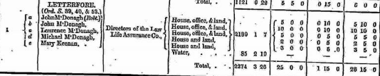
In Griffith’s Valuation the area is 2274 acres 38 perch with a land value of £25 0s 0d, value of buildings £1 15s 0d , and the total value is £26 15s 0d. Area of water was 85 acres 2roods 10 perches.
Occupiers of the Land :
The occupiers of the land at this time were:
John Mc Donagh, a second landowner named John McDonagh also, Lawrence McDonagh, Michael McDonagh and Mary Keenan.
The Landlord or immediate leasers was Directors of the Law Life Assurance Co.
Ownership of Land and Property
The two John McDonaghs and Laurence McDonagh owned a house, out office and land while Michael Mc Donagh and Mary Keenan owned a house and land.
Annual Valuation The total annual valuation of rateable property in Letterfore came to £26 15s 0d.
Land Rates : John and Lawrence McDonagh were rated at £5 0s 0d each while John McDonagh was rated £10 0s 0d, Michael Mc Donagh £2 0s 0d and Mary Keenan £3 0s 0d.
Building Rates : The two John Mc Donagh’s rates on buildings were 10s each and Michael, Lawrence Mc Donagh and Mary Keenan each paid 5s each.
http://www.askaboutireland.ie/griffith-valuation/index.xml?action=doNameSearch&PlaceID=559049
View the heads of households in the townland at this time.
Poor Law Union Ireland
In Ireland the Poor Relief Act of 1838 divided into districts or “unions” in which the local taxable inhabitants were to be financially responsible for all paupers in the area. In 1898 the Poor Law Union was adopted as the basic administrative division in place of the civil parish and barony. Further subdivision into 828 registration districts and 3,751 district electoral divisions followed. Townlands were not arranged according to these divisions with parish and barony retained as a means to make comparisons with records gathered before 1898.
The 1838 Act
The main provisions of the 1838 Act were:
- The extension of the existing Poor Law Commissioners’ powers to Ireland, with the appointment of Assistant Commissioners who were to implement the Act in Ireland.
- The division of the country into Poor Law Unions based on Irish electoral divisions which were themselves made up from townlands.
- The creation of a Board of Guardians for each Union, two-thirds of whom were to be elected, the other third to be appointed ex officio.
- The setting up of a workhouse in each Union.
- The collection of a local poor-rate to finance the system.
- Assistance for emigration.
Initially, 130 Unions were created, based upon 2,049 electoral divisions. The divisions were composed of townlands, a peculiarly Irish unit, traditionally of 120 Irish acres in area. (Between 1848 and 1850, an additional 33 Unions were created by subdividing and reorganizing the boundaries of some existing Unions, particularly in the west of the country.
Boards of Guardians were elected annually on 25th March. Only rate-payers were eligible for election, which effectively disenfranchised most of the native Irish who were usually tenants at this time. Rate-payers were allowed between one and six votes depending on the size of a valuation of their property.
Out Offices and Land
The out office was a farm building, a cow house, piggery or barn. The land was very poor and sterile and people were always poverty-stricken. At this time most tenants were trying to eke out a living on 5acres or less and a farmers needed at least 15.3 acres to survive.
Clachan: The Irish is ‘Clochán’. The houses in Letterfore formed a Clachan. A clachan was a small traditional settlement common in Ireland until the middle of the 20 th century. They usually lacked a church, post office or other formal building. The origin is unknown but it is likely that they are of ancient root most likely dating to medieval times.
The Letterfore clachan was a cluster of small single storey farmers’ cottages built on poor land. They were related to the rundale system of farming. According to David Lloyd, The Great Famine 1845–1849 caused such disruption to the social system that the clachans virtually disappeared.
People living in Clachans had the support of a tight knit community.
In some cases the clachans have evolved into holiday villages or one or two houses have been taken over turning smaller houses into agricultural outhouses.
Townlands
A town land is one of the smallest land divisions in Ireland. They range in size from a few acres to thousands of acres. Many are Gaelic in origin, but some came into existence after the Norman invasion 1169. Letterfore is a townland.
Population & Census Information
People who lived here:
You can retrieve a list of people who lived in this townland from 1827 to 1911. This list is compiled from the following resources.
- The Tithe Applotment Books
- Griffith’s Valuation
- 1901 Census
- 1911 Census
List of nineteenth century and early twentieth century inhabitants of this townland.
1841-1891 Census
1841 – 14 houses with 65 people
1851 – 9 house with 44 people
1861 – 6 houses with 38 people
1871 – 9 houses with 40 people
1881 – 6 houses (6 inhabited) with 29 people (17 males, 12 females). There were 13 outbuildings.
The valuation of Houses & Land in 1881 was £26 15s 0d.
1891 – 6 houses (6 inhabited) with 26 people (15 males, 11 females). There were 17 outbuildings.
The valuation of Houses & Land in 1891 was £27 5s 0d.
1901 Census Letterfore
This is a return of the members of the family, their Visitors, Boarders, Servants who slept or abode in their house on the night of Sunday March 31st1901 in Letterfore There were 6 houses listed in the Townland of Letterfore. The people were all Roman Catholics and they were born in County Galway. There were 14 in total of farm buildings and out offices which included, stables, calf houses, cow houses, sheds, barns and piggeries.
Class of House: The class of house depended on the materials used in the roof, walls, number of rooms and number of front windows. A 1st class house was considered the highest standard.
Walls of the houses: The walls were of stone, brick, concrete or of mud, wood or other perishable material. The houses in Letterfore were built of stone, brick or concrete. There were no mud cabins.
Roofs: Roofs were of slate, iron, tiles, thatch, wood or other perishable material. The roofs of houses were of thatch, wood or perishable material. Most likely they were thatched as there was ample reeds for thatching in the lakes.
House Occupancy: Each of the 6 houses was occupied by one family.
The people listed as Head of the Family were also listed as the lawful Landholder of the property. There was a population of 34 – 17 males and 17 females residing in the village.
Enumerators Extract
http://www.census.nationalarchives.ie/reels/nai000840399/
House & Building Returns
http://www.census.nationalarchives.ie/reels/nai000840400/
Out Offices & Farm Steadings
http://www.census.nationalarchives.ie/reels/nai000840401/
House 1: Lawrence McDonagh aged 70 was head of the family. He lived with his wife Honor aged 75. Lawrence was a farmer. He had 2 cow houses. Living with him were his son Michael aged 38 and his wife Ellen aged 32. Michael and Ellen’s children lived in the house too. Mary 9, Lawrence 8, Moya 7, John 6, Michael 5, Eddy 3 and Tom 1. The family could read and write except for the younger children. The family spoke English and Irish. They lived in a Class 2 house with 3 front windows. 11 persons occupied 3 available rooms.
http://www.census.nationalarchives.ie/pages/1901/Galway/Letterfore/Letterfore/1394496/
House 2: Michael McDonagh aged 57 was head of the family. Living with him was his wife Honor aged 40 and their children – Thomas 18, Michael 14, Ellen 12, Margaret 10, Bridget 8 and Honor 3. The family spoke English and Irish and they could read and write except for the younger children. Michael was a farmer and his sons Michael and Thomas were listed as farmer’s sons while the younger children were scholars. They had a stable, cow house and a piggery. 8 persons lived in a Class 3 house with one front window. The family occupied 3 available rooms.
http://www.census.nationalarchives.ie/pages/1901/Galway/Letterfore/Letterfore/1394497/
House 3: John McDonagh aged 45; a widower was head of the family. Living with him was his son John 22 single. They could read and write and spoke Irish and English. They had a stable, cow house and a piggery. They lived and a Class 3 house with one front window. 2 persons occupied 2 available rooms.
http://www.census.nationalarchives.ie/pages/1901/Galway/Letterfore/Letterfore/1394498/
House 4: Margaret McDonagh aged 65 and a widow was Head of the Family. Living with her was her nephew Patrick Toole aged 11 and her niece Kate Toole 26 who was single and a farmer’s daughter. Kate spoke Irish. Margaret and Patrick spoke Irish and English. Patrick could read and write but Margaret and Kate could not read. Margaret was a farmer and had 1 cow house. She lived in a Class 3 house with 2 front windows. 3 persons occupied 3 available rooms.
http://www.census.nationalarchives.ie/pages/1901/Galway/Letterfore/Letterfore/1394499/
House 5: Thomas McDonagh aged 42 and Head of the Family lived with his wife Bridget 30. Their children May Margaret 10, Bridget Anne 8, Patrick Joseph 6, John 5, James 2 and Mary 3months lived with them in a Class 3 house with one front window. The family could read and write except for the younger children. The family spoke Irish and English. Thomas was a farmer. He had a stable, cow house and calf house. 8 persons occupied 3 available rooms.
http://www.census.nationalarchives.ie/pages/1901/Galway/Letterfore/Letterfore/1394500/
House 6: Robert McDonagh aged 50, a farmer was head of the Family He lived with his wife Mary 33. They could read and write and they spoke Irish and English. The lived in a Class2 house with 4 front windows. They had a stable and a cow house. 2 persons occupied 3 available rooms.
http://www.census.nationalarchives.ie/pages/1901/Galway/Letterfore/Letterfore/1394501/
1911 Census Letterfore
This is a return of the Members of families in Letterfore, their visitors, boarders and servants who slept or abode in the house on the night of Sunday the 2nd of April 1911.
Description of the Houses All the houses in Letterfore were listed as private dwellings and were built of concrete or stone. The roofs of the houses were of wood, thatch or other perishable material. Most likely they were thatched. The heads of the families were listed as the landholders. One family lived in each property. The Class of the house depended on the material used in the roof, walls, number of rooms and number of front windows. Most of the houses came under “2’ in the census form meaning that there could be 2, 3, or 4, rooms in the house.
General Information : One family lived in each of the 6 houses listed. They were all Roman Catholics and the head of the family was the landholder. There were 17 males and 14 females a total of 31 persons living in the village. There was a total of 23 farm buildings in the village.
Enumerators Extract
http://www.census.nationalarchives.ie/reels/nai002434997/
House & Building Returns
http://www.census.nationalarchives.ie/reels/nai002434999/
Out Offices & Farm Steadings
http://www.census.nationalarchives.ie/reels/nai002435001/
House 1:Robert McDonagh aged 69 was head of the family. He was a farmer and lived with his wife Mary 48 and daughter Mary Jane 12. He was married 13 years and could read and write and spoke English and Irish. He had one child born alive and one still living. He lived in a Class 2 house with 4 front windows. 3 persons occupied 3 available rooms. He had a stable, cow house and shed.
http://www.census.nationalarchives.ie/pages/1911/Galway/Letterfore/Letterfore/912192/
House 2: Thomas McDonagh aged 55 was head of the Family. His wife Bridget 43 lived with him and his children – Patrick Joseph 16, John 14, James 12, Robert 8, Barbara 6, Nora 4 and Edward 1. They were married for 20 years. 10 children were born alive and 10 were still living. The family could read and write and they spoke English and Irish. They lived in a Class 2 house with 3 front windows. 9 persons occupied 3 available rooms. They had 2 cow houses, a calf house and a piggery.
http://www.census.nationalarchives.ie/pages/1911/Galway/Letterfore/Letterfore/912193/
House 3: Margaret Toole aged 40 was Head of the Family. Living with her were a son and daughter – Patrick 20 and Julia 16. All three spoke Irish and English. Bridget couldn’t read but Patrick and Julia could.
Note: Thomas Toole head of the Family resides in Leam a second house that is constantly occupied by the family.
Bridget and Thomas were married 20 years. 6 children were born alive and 6 are still living. They live in a Class 3 house with 2 front windows. 3 persons occupied 2 available rooms. They have a cow house, calf house and a piggery.
http://www.census.nationalarchives.ie/pages/1911/Galway/Letterfore/Letterfore/912194/
House 4: Mary McDonagh aged 65 was Head of the Family. A widow she lived with her son John 32 a farmer’s son who was single. They could read and write and spoke English. They lived in a Class 2 house with 3 front windows. 2 persons occupied 3 available rooms. They had a stable, cow house and piggery.
http://www.census.nationalarchives.ie/pages/1911/Galway/Letterfore/Letterfore/912195/
House 5: Michael McDonagh a farmer, aged 60, was Head of the Family. He lived with his wife Ellen 50. They were married for 20 years and 10 children were born alive and 9 were still living. Living with them were Mary 17 and Lawrence 15 – listed as farmer’s daughter and farmer’s son. Maggie 15, Michael 13, Thomas 12 and Joseph 6 were scholars. They all could read and write and they spoke English and Irish. They lived in a Class 2 house with 3 front windows. 8 persons occupied 3 available rooms. They had a stable, 2 cow houses, shed and a piggery.
http://www.census.nationalarchives.ie/pages/1911/Galway/Letterfore/Letterfore/912196/
House 6: Michael McDonagh aged 71 a farmer was head of the family. He was married to Honor 40. The family could read and write and spoke Irish and English. They were married 28 years. 9 children were born alive and 6 were still living. Thomas 24, Michael 20, Bridget 17 and Nora 14 listed as farmer’s sons and daughters lived with them in a Class 2 house with 3 front windows. 6 persons lived in 3 available rooms. They had a stable, 2 cow houses, piggery and a shed.
http://www.census.nationalarchives.ie/pages/1911/Galway/Letterfore/Letterfore/912197/
Church records of births, deaths and marriages:
Church records of births, deaths and marriages are available online at http://www.rootsireland.ie. To search these records, you will need to know the ‘church parish’ rather than the ‘civil parish’. (The civil parish is the pre-reformation parish and was frequently used as a unit of administration in the past.)
Glencoh is in the civil parish of Kilcummin.
Roman Catholic parishes:
This civil parish corresponds with the following Roman Catholic parish or parishes.
- Carraroe
- Kilannin
- Kilcummin/Oughterard
- Rosmuc
Church of Ireland parishes:
This civil parish corresponds with the following Church of Ireland parish.
- Kilcummin
In general, the civil parish and the Church of Ireland parish are the same, but, this is not always the case.
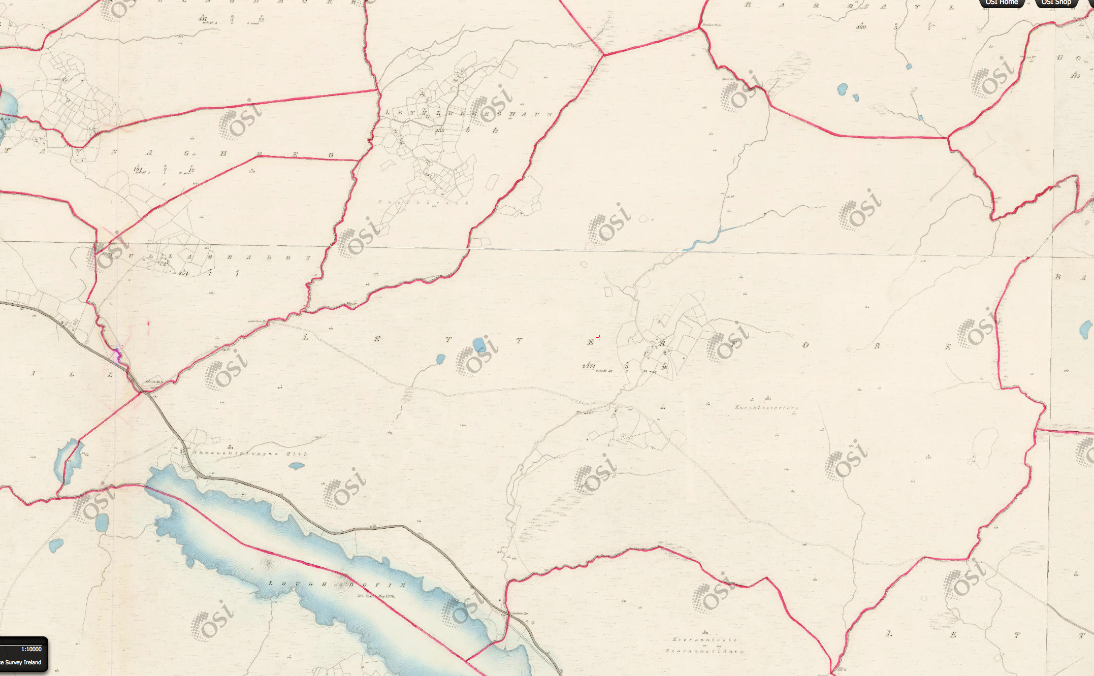
Map
It is located at 53° 27′ 44″ N, 9° 28′ 49″ W.
Original OS map of this area. Ireland was first mapped in the 1840s. These original maps are available online.
Original OS maps at the Ordnance Survey of Ireland website.
Below is a link to the Ordnance Survey of Ireland website. It displays the original OS map that was created in the 1840s.
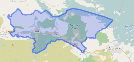
Information from Google Maps.
You can use this link to find this townland on Google Maps
Information from the National Monuments Service.
You can use this link to view a map of archaeological features. This link brings you to a website wherein you will have to search for your townland.
Archaeological map from the National Monuments Service
Galway Library Website
http://places.galwaylibrary.ie/place/52886
Townlands.ie Website
https://www.townlands.ie/galway/letterfore/


No Comments
Add a comment about this page