Excavation Reports Donaghpatrick-Kilcoona: 1. Bunnasillagh 1953


A number of published archaeological excavations have taken place in the parish of Donaghpatrick-Kilcoona, some dating back to the 1950’s. These excavation reports have been uploaded to excevations.ie, the Database of Excavation Reports. These reports were compiled by the archaeological teams involved in each excavation and will be uploaded individually as part of a series of publications relating to the excavations in the parish. The findings of these excavations vary in detail, however, despite the scant findings of some of the excavations, the individual reports provide rich details on processes and techniques used by the archaeologists.
The first excavation of this series dates from a discovery of an ancient burial site in December 1953 in the townland of Bunnasillagh. The excavation took place in early January 1954.
https://excavations.ie/report/1953/Galway/0028556/
1953:011 – BUNNASILLAGH, CO. GALWAY, E1070, Galway
County: Galway
Site name: BUNNASILLAGH, CO. GALWAY, E1070
Sites and Monuments Record No.: SMR GA042-229SMR GA042-046
Licence number: E1070
Author: ELLEN PRENDERGAST
Site type: Graves of indeterminate date
Period/Dating: —
ITM: E 530756m, N 750040m
Latitude, Longitude (decimal degrees): 53.495812, -9.043565
Introduction
In December 1953 a human skull was identified after falling out of the section of a sandpit near Headford, Co. Galway. By the time the site was reported to the NMI by the Garda Síochána at Headford, work had moved to another part of the sandpit and the burial had been left intact pending an investigation. The site was investigated on 5 January 1954 by Ellen Prendergast. The human remains from the site were examined by Mr D.M. Davies. This report is based on
Prendergast’s excavation report and on Davies’s analysis of the bone.
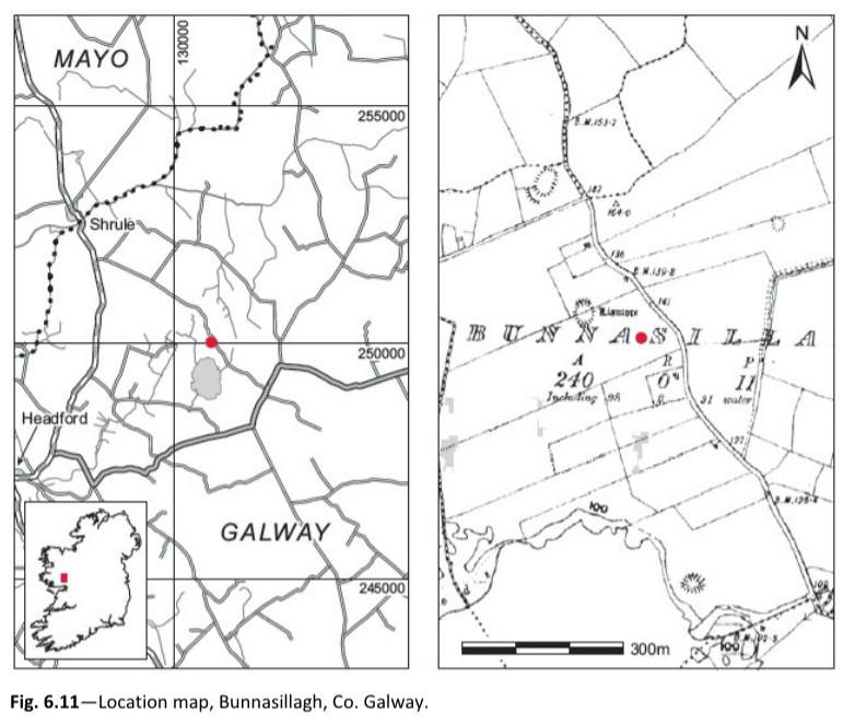
Location (Fig. 6.11)
The site was in the townland of Bunnasillagh, in north County Galway, close to the border with County Mayo. 17 It lay immediately west of the Shrule road in the same field as a ringfort marked
‘Lismore’ 18 on both editions of the OS 6in. sheet, at 30–40m above sea level. The burial was at the top of a small sandpit, about half of which had been removed in recent years by Mr Walter Keady, the landowner. According to Mr Keady, bones had not been noticed here before. The skull lay approximately 0.5m under the ground surface. No sites of similar type are known from the
immediate area.
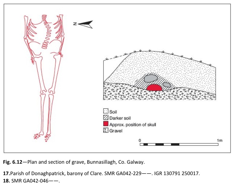
Description of site
The ground surface immediately above the grave had fortunately been left intact. Although the
grave did not appear to be stone-lined, some stones of varying sizes lay around the body (Fig. 6.12). The grave was aligned east/west. The soil near the bones was dark and loose, and it appeared from the section in the sandpit that the grave had been partly cut into the sand.
Comment
The grave contained a single extended inhumation (1953:47) without any accompanying artefacts. According to Davies’s analysis, the bones represented a male of about 40 years of age, apparently a hunchback. Both the skull, which had shattered when it fell out of the section, and the clavicles were missing, but the remainder of the skeleton was intact. The body lay fully extended, in a supine position with the feet to the west and head to the east. The arms were extended by the sides.
The above information was taken from www.excavations.ie – a national database for excavations in Ireland, under the Department of Housing, Local Government and Heritage.
No Comments
Add a comment about this page