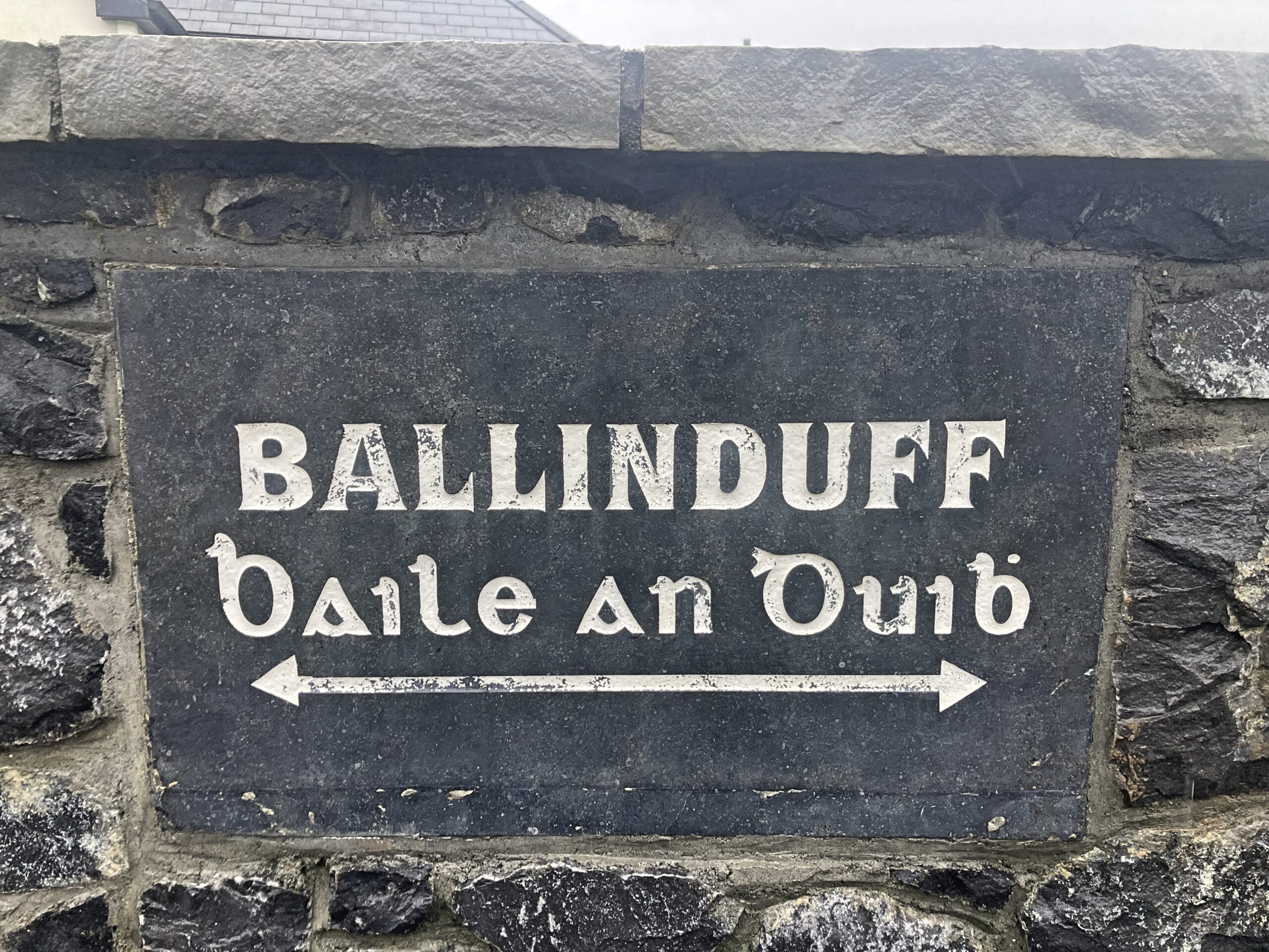
Ballinduff (Baile An Duibh)


The name Ballinduff comes from the Irish Baile An Duibh, meaning the townland of the black earth. It is situated in the civil parish of Kilcoona, Barony of Clare. It is located in the south of the parish and is bounded on the east by Inish and Ballynew, on the west by Luimnagh West and Luimnagh East and on the north by Ballydonnellan. (Source: Galway Library).
Irish name: Baile An Duibh
English name: Ballinduff
Meaning: The townland of the black earth or the town of the black man
Area: 297 Acres, 2 roods, 8 perches
Field names:
Civil Parish: Kilcoona
Barony: Clare
O’Donovan’s Field Name Books
As part of the Ordnance Survey of Ireland, from 1830 to 1842, John O’Donovan helped to collect and record the Irish form of townland names throughout the country. Information for each townland was collected and written into the Name Book along with information relating to land quality, crops and housing. (Source: Timeline Genealogy)
Other names: Ballinduff, Baile an Duibh, Ballinduff (Boundary Surveyors Sketch Map), Ballinduff (County Cess Collector), Ballinduff (County Map), Ballinduffe (Inq. Temp. Jac. I),
Ballinduff (Local), Ballinduff (Mearsman), Balinduff (Rental), Ballinduff (Revd. John Molloy, P.P.) and
Ballenduff (Tithe Ledger).
Description: Proprietor John Skerrett, Esqr., Athgoe Park, Dublin. Agent Dominick Donnellon, Esq., Mount Tully, Tuam. Rent 22 shillings per acre. This farm is 44 acres, other farms here are sold for a bulked rent. The quality being bad. Crops some light and part middling wheat, potatoes and some oats and rocky pasture. Co. Ces 14d. paid per acre. The Lodge and offices of Ballinduff stand near the southern part of this townland. Antiquities an old castle near the Lodge.
Other placenames in this townland
Ballinaparky (Village) Name given to Southern part the townland Ballinduff.
Ballinduff Castle In ruins; said to have belonged to the Skerretts. Situated near the Lodge offices of Ballinduff.
Ballinduff Lodge Former residence of John Skerret. Situated in the townland of Ballinduff.
Castle Parks Name given to Demesne. Situated in the N. side of Ballinduff townland.
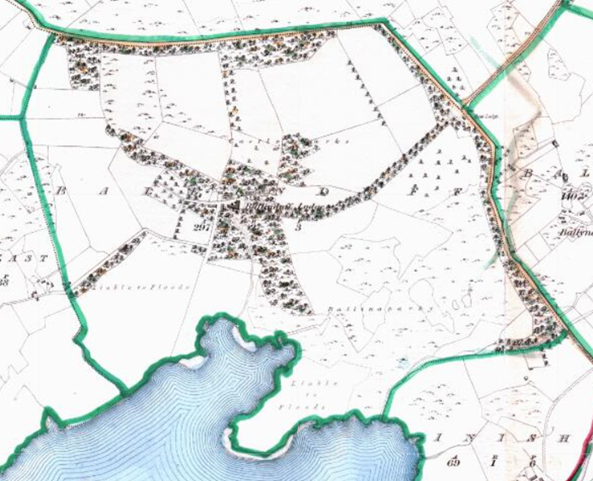
The Down Survey
The first national-scale survey of its kind in the world, the Down Survey, taken in the years 1656 -1658, sought to acurately map the land in Ireland in order to facilitate its transfer from Irish Catholics to English Protestants after the Cromwellian conquest.
1641 (pre-Cromwell) states that the owner(s) of the townland of Ballinduff Referred to as (Castle Quarter in the Down Survey of Ireland, in the Parish of Killcoonagh in the county of Galway, Barony of Clare) was the Edund oge McEdmund (Catholic). The Down Survey map of 1670 (post-Cromwell) shows that the owner(s) were Colonel William Legg and Dominick Skerrett (Protestant). (Source: Trinity College Dublin)
There is no information related to land area and quality.
Tithe Applotment Book 1826
The Tithe Applotment Books were compiled between 1823 and 1837 in order to determine the amount which occupiers of agricultural holdings over one acre should pay in tithes to the Church of Ireland. The land was measured in Irish acres, or plantation acres at the time. This equated to 1.698 English acres.
There were no records found for Ballinduff.
1851 Old Age Pension Census Search Forms
There were no records found for Ballinduff.
Valuation Office Books 1824-1856: House & Field Books
The valuation of Ireland was a cadastral survey made for the purpose of levying tax on property. A valuation price was put on every piece of property in the country and this became the basis on which local tax was charged, at a rate per pound of valuation. (Source: National Archives)
The 1843 Field Books show the following as land occupiers in Ballinduff John Skerritt (23 November 1843). (Source: National Archives)
There was 297 acres, 2 roods and 3 perches valued in Ballinduff which had a value of £103 and 18 shillings. The land was valued by David Willamson. On 27 January 1846, a valuator named Martin Coffey reduced the land valuation to £87 and 16 shillings
John Skerritt occupied a house and offices which were valued at £7 and 4 shillings.
The 1845 Field Books show the following as land occupiers in Ballinduff John Skerritt (03 April 1845). (Source: National Archives)
There was 297 acres, 2 roods and 3 perches valued in Ballinduff which had a value of £103 and 18 shillings. John Skerritt’s house and offices were valued at £7 and 4 shillings.
The 1845 House Books show the following as house occupiers in Ballinduff as John Skerritt and Michael Tierny (12 July 1845). (Source: National Archives)
The valuator David Williamson gave an initial buildings valuation of £4 and 2 shillings and 11 pence for those held by John Skerritt. This amount was amended by another valuator named Martin Coffey to £4 and 8 shillings. One of the valuators noted that the property was “well situated near the lake but unoccupied”. The valuation document noted that Michael Tierny was exempt from the valuation.
The 1846 House Books show the following as house occupiers in Ballinduff as John Skerritt and Michael Turner (27 January 1846). (Source: National Archives)
Properties associated with John Skerritt were valued at £12 and 5 shillings and 6 pence. Valuations related to Michael Turner could not be deciphered due to the poor quality of the image.
The 1853 House Books show the following as house occupiers in Ballinduff as William Kavanagh, Thomas Newil, Michael Breheny, John Fallon, Michael Tierney, James Devany and John Skerrett (06 September 1853). (Source: National Archives)
William Kavanagh occupied a House (the Offices were in another townland) that had an initial valuation of £1 and 4 shillings which was reduced to 12 shillings by the valuator. Thomas Newil occupied a House that had an initial valuation of £1 and 8 shillings which was reduced to 15 shillings by the valuator. Michael Breheny occupied a House that had an initial valuation of 7 shillings which was reduced to 4 shillings by the valuator. John Fallon occupied a House that had an initial valuation of £1 and 8 shillings which was reduced to 15 shillings by the valuator. Michael Tierney occupied a House and Offices that had an initial valuation of £3 and 9 pence which was reduced to £1 and 10 shillings by the valuator. James Devany occupied a House and Offices that had an initial valuation of £2 and 18 shillings which was reduced to £1 and 10 shillings by the valuator. John Skerrett occupied Offices that had an initial valuation of £1 and 17 shillings which was reduced to £1 by the valuator.
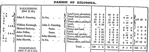
1855 Griffith’s Valuation
Between 1847 and 1864, Richard Griffith was responsible for carrying out the Primary Valuation of Tenements (generally referred to as Griffith’s Valuation because of his role in the project). The aim of the valuation was to produce a uniform guide to the relative value of land throughout the whole of Ireland in order to decide liability to pay the Poor rate (for support of the poor and destitute within each Poor Law Union). The project required Griffith and a team of valuers to determine the value of every piece of land and property in the country enabling every occupiers’ tax due to be assessed. The information they collated covering all 32 counties was compiled into over 300 volumes and published over a period of 17 years. (Source: Find My Past)
Griffith’s Valuation records the following occupiers in Ballinduff as Michael Breheny, James Devany, John Fallon, John J. Gunning, William Kavanagh and John Skerritt. (Source: Ask About Ireland)
John J. Gunning occupied the following property ‘In Fee’*; land (part plantation) measuring 56 acres and 9 perches which was valued at £20; house and plantation (6 acres, 3 roods and 8 perches), the valuation of the plantation was £1, while the house was 10 shillings; land, measuring 45 acres, 3 roods and 8 perches with a valuation of £18 and a house with offices and land (81 acres, 3 roods and 8 perches), the land valuation was £18 and 10 shillings, while the buildings valuation was £1 and 10 shillings.
* Lands held ‘in fee’ were freehold tenures, derived from a grant from the Crown.
William Kavanagh occupied a house and land (6 acres, 3 roods and 32 perches), the land had a valuation of £4, the house had a valuation of 10 shillings. The immediate lessor was John J. Gunning.
Michael Breheny occupied a house and land (3 acres, 1 rood and 27 perches), the land had a valuation of £2, the house had a valuation of 5 shillings. The immediate lessor was John J. Gunning.
John Fallon occupied land (5 acres, 3 roods and 35 perches), the land valuation was £2 and 13 shillings. In addition, John Fallon occupied a house and garden (1 rood and 14 perches), the house valuation was 10 shillings, the garden valuation was 2 shillings. The immediate lessor was John J. Gunning.
James Devaney occupied a house, offices and land (7 acres, 3 roods and 30 perches), the land had a valuation of £4, the buildings had a valuation of £1. In addition, James Devaney held plantation lands (5 acres, 1 rood and 18 perches) with a valuation of £1 and 10 shillings. The immediate lessor was John Skerritt.
John Skerritt occupied the following property ‘In Fee’, house, offices and land (79 acres and 16 perches), the land had a valuation of £24, the house had a valuation of £2.
* Lands held ‘in fee’ were freehold tenures, derived from a grant from the Crown.
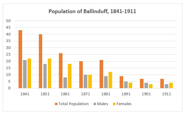
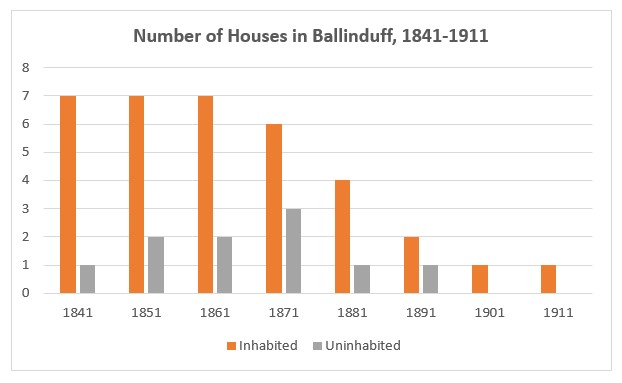
Population Statistics
The following statistics are from the census return records from 1842 to 1891 and the National Archives census returns for 1901 and 1911. (Source: Histpop)
1841: 7 houses (incl. 1 unoccupied), 43 people (21 males and 22 females)
1851: 7 houses (incl. 2 unoccupied), 40 people (18 males and 22 females)
1861: 7 houses (incl. 2 unoccupied), 26 people (8 males and 18 females)
1871: 6 houses (incl. 3 unoccupied), 20 people (10 males and 10 females)
1881: 4 houses (incl. 1 unoccupied), 21 people (9 males and 12 females)
1891: 2 houses (incl. 1 unoccupied), 9 people (5 males and 4 females)
1901: 1 house, 7 people (4 males and 3 females)
1911: 1 house, 7 people (3 males and 4 females)
1901 Census
The 1901 Census of Ireland records the following 7 individuals living in 1 household in Ballinduff. (Source: National Archives)
1. James Cunningham (55) lived with his wife Honor (51), sons Patt (28), James (26) and Thomas (20), daughter Julia (14) and female relative Bridget Divilly (49). All householders were born in Co Galway and all were Roman Catholic. James’ occupation was listed as a Farmer, Honor as a Farmer’s Wife, Patt, James and Thomas were listed as Farmer’s Son while Julia was listed as a Scholar. Bridget Divilly was listed as a Farm Servant. All householders could read and write. All householders could speak Irish and English.
There was no information on out-offices and farm steadings.
1911 Census
There was 1 house in Ballinduff with a total of 7 individuals recorded in the 1911 Census of Ireland. (Source: National Archives)
1. James Cunningham (70) lived with his wife of 42 years Honor (68), sons Patrick (41) and James (38), daughter Julia (23), sister-in-law Bridget Devilly (66), and niece Bridget Flaherty (9). All householders were born in Co Galway and all were Roman Catholic. James’ occupation was listed as a Farmer, no occupation was listed for Honor, Patrick and James were listed as Farmer’s Son while no occupation was listed for Julia and Bridget Divilly. Bridget Flaherty was listed as a Scholar. All householders could read and write. All householders could speak Irish and English. James and Honor had 7 children, 6 of whom were alive in 1911.
There was one second class in Ballinduff in 1911. The house had a roof of either slate, iron or tiles. The house had walls constructed of either brick, stone or concrete. The second-class house had two front windows. There were 2 stables, 1 cow house, 1 calf house, 1 piggery, 1 fowl house, 1 barn and 1 shed.
No Comments
Add a comment about this page