
Translation: A ridge
The Down Survey: The Down Survey of Ireland is the first ever detailed land survey on a national scale anywhere in the world. The survey is a cadastral survey of Ireland and was so called simply by its topographic details all laid down by admeasurements on maps. It was carried out by William Petty an English scientist in 1655 and 1656. The survey sought to measure all the land to be forfeited by the Catholic Irish, in order to facilitate its redistribution to merchant adventurers and English officers and soldiers in Oliver Cromwell’s army. It was to repay them and the many English politicians and adventurers who had funded Cromwell’s military campaign in Ireland.
The Down Survey name for the townland was Druimm. In 1641 (pre-Cromwell) the owners were Murrogh McBrien O’Flahartye, Thom McEdmund McRickard Shoy, Edmund McWalter Oge Shoy and Andrew Lynch FitzWilliam; all Catholic. In 1670 (post Cromwell) it was in protestant ownership of College of Dublin. There were 77 plantation acres of unprofitable land; 17 plantation acres of profitable land and this amount was forfeited. It is in the half barony of Rosse (sic) in the parish of Rosse and is in County Galway.
O’Donovan’s Field Name Books 1838: John O’Donovan tells us the standard name for the townland is Drin and Druinn is the Irish form of the name that translates as ‘a ridge’.
Other forms of the name: Drin, Drinn, Drin (Boundary Sketch Map), Drinn (County Cess Collector), Drin (Local), Drin (Mearsman), Drinn (Rev. Michael Heraghty P.P.), Drinn (Tithe Ledger), Droin (Inquis. Temp. Gul).
Description: The proprietor was the Provost of Trinity College Dublin (T.C.D.). The agent was Alexander Nesbitt, Esq., Junior, of 96 Stephens Green South, Dublin. The land was all held under lease by John Fair Esq., Rathmines Dublin for a rent of £18 and 12 shillings. The soil consisted of steep heath rough pasture and some arable mountain, coarse mixed pasture with some tillage at the valley. The crops of oats were middling; potatoes were part middling and some were bad. The Co. Cess of 11¼d was paid per acre half yearly for 70 acres. Drin is a village with ruins of Do Illaun. Illaun – na – neenee – morriv (sic) on Lough Mask translates as ‘Island of the dead men’. There are no antiquities. Finny river runs between Drin and Finny.
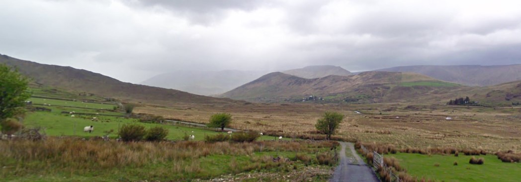
Situation: Drin is a central townland bounded on the north by the townlands of Cummer and Kangarrow (sic); on the west by Kangarrow, to the south by Toorloggagh and on the east by Lough Mask and Finny. It is in the barony of Ross and is in Co. Galway.
Griffith’s Valuation 1849: Drin can be found on Ordnance Survey Sheet 13 and 26. Griffith’s Valuation revealed it had an area of 697 acres and 14 perches. The land, all held by Robert Phayre contained 697 acres, 3 roods and 2 perches. He had only one tenant on Plot 1.
Plot 1: Peter Gaynor had a house, offices and land. The land had an annual valuation of £36 and the buildings, an annual valuation of 15 shillings. Peter paid a total annual rent of £36 and 15 shillings.
1901 Census: Constable Patrick McShane enumerated the census return for Drin on the 14th of April 1901. Drin was in the constabulary district of Clonbur and in the sub-district of America Hut. Two 3rd class dwellings with perishable roofs, that were most likely thatch accommodated six people: three males and three females. All were born in Co. Galway and were Roman Catholic.
No 1: Thomas Jennings (60), his wife Catherine (45) and their two children lived here. Thomas was a farmer; James (25) a farmer’s son and Margaret (10) was a scholar. Thomas could read; Catherine and the children could read and write, and all spoke Irish and English. The house was 3rd class with two windows in front and the family of four occupied two rooms. They had a cow house and a barn on the holding.
No 2: John Joyce (60) a herd and his wife Sarah (60) were the occupiers of this house. John could read and write; Sarah could not read; both were bilingual. The house was 3rd class with one window in front and the couple occupied two rooms. They too had a cow house and a barn on their holding.
Mrs. Rutledge Fair was the name of the landholder where both houses were situated.
1911 Census: Constable Patrick Breheny (sic) collected the census return on the 8th April 1911. Two 3rd class dwellings remained in the townland of Drin. Seven people resided here: four males and three females. One was born in Co. Mayo and the remainder born in Co. Galway; all were Roman Catholic.
The 1911 census was expanded to include the number of years a couple were married and the number of children born to them. It revealed that child mortality was high at the time. Sometimes discrepancies in age, and spellings of names occur between the 1901 and the 1911 census returns.
No 1: Tom Jennings (77) a farmer was married to Kate (67) for forty years and they had seven children; two were still living and one was recorded in this census. Their son James (40) a farmer’s son and his wife Ellin (sic) (33) were married for two years and they had a (1) year old son Tom. Tom senior could not read; Kate and the young couple could read and write; all spoke Irish and English. The house was 2nd class with three windows to the front and five people occupied three rooms. They had four out offices that contained a stable, a cow house, a calf house and a barn.
No 2: John Joyce (80) and his wife Sarah (79) were married for thirty years and they did not have children. Farming was their way of life. Neither could read (the 1901 census states that John could read and write), both were bilingual. The house was 3rd class with two windows in front and the couple occupied two rooms. They had a cow house and a calf house on the holding.
Tom Jennings was the name of the landholder where this house was situated.
No Comments
Add a comment about this page